
 1 month ago
55
1 month ago
55
Goodbye, Debby. Now it's time to keep an eye on a tropical wave.
Six days after the storm's first landfall as a hurricane in Florida, then a second landfall as a tropical storm in South Carolina, the National Hurricane Center released its last advisory on Debby on Aug. 9. The storm brought historic rainfall from Florida to the Carolinas.
➤ Weather alerts via text: Sign up to get updates about current storms and weather events by location
Elsewhere in the tropics, a new tropical wave in the Atlantic is likely to become a tropical depression early next week as it approaches the Lesser Antilles and Caribbean Sea.
If it does become a named storm, it will be Ernesto.
Tropical Storm Debby made its second landfall just before 2 a.m. Thursday, Aug. 8, near Bulls Bay, South Carolina. Sustained winds were 50 mph.
Debby's first landfall was as a hurricane in Steinhatchee, Florida, around 7 a.m. Monday, Aug. 5. Sustained winds were 80 mph.
Here's the latest update from the National Hurricane Center in Miami as of 8 a.m. Aug. 10:
Near the Lesser and Greater Antilles (AL98): Shower and thunderstorm activity has increased since Aug. 9 in association with a tropical wave located roughly midway between the Cabo Verde Islands and the Lesser Antilles. Gradual development of this system is possible during the next couple of days while it moves westward to west-northwestward across the central tropical Atlantic.
Afterward, conditions are expected to become more conducive for development, and a tropical depression is likely to form by the early to middle part of next week while the system approaches and then moves near or over the Lesser Antilles. The system is forecast to continue moving generally west-northwestward and could approach portions of the Greater Antilles by the middle to latter part of next week.
Formation chance through 48 hours is low at 30 percent.
Formation chance through 7 days is high at 80 percent.
Colorado State University predicts 85% chance for hurricane activity through Aug. 19
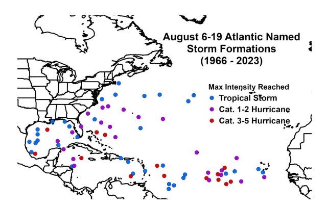
Atlantic named storm formations from Aug. 6-19 from 1966–2023 and the maximum intensity the named storms reached.
CSU forecasters predict there is an 85% chance for hurricane activity from Aug. 6 through Aug. 19.
"The primary threat formation area for major hurricanes in early- to mid-August is in the tropical Atlantic east of the Lesser Antilles."
The next two-week forecast will be released Aug. 20 for Aug. 20-Sept. 2.
On Aug. 6, CSU updated its seasonal forecast for the 2024 Atlantic hurricane season, reducing the predicted number of named storms from 25 to 23 but maintaining its forecast for 12 hurricane and six major hurricanes.
What do the colored areas on the NOAA map mean?
The hatched areas on a tropical outlook map indicate "areas where a tropical cyclone — which could be a tropical depression, tropical storm or hurricane — could develop," said National Hurricane Center Deputy Director Jamie Rhome.
The colors make it visibly clear how likely a system could develop with yellow being low, orange medium and red high.
The National Hurricane Center generally doesn't issue tropical advisories until a there is a named storm, but there is an exception.
"If a system is near land and there is potential for development, the National Hurricane Center won't wait before it issues advisories, even if the system hasn't become an actual storm. This gives residents time to prepare," Rhome said.
Who is likely to be impacted?
It's too early at this time to determine if there will be any impact to Florida or the U.S. from the tropical wave in the Atlantic.
Forecasters urge all residents to continue monitoring the tropics and to always be prepared. That advice is particularly important for what is expected to be a very active hurricane season.
NOAA updates 2024 hurricane season forecast
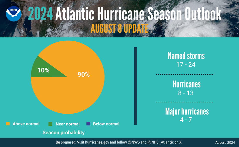
NOAA updated its 2024 Atlantic hurricane season forecast on Aug. 8, 2024.
NOAA has updated its prediction for the 2024 Atlantic hurricane season, more than two months and four named storms after its first prediction was released in May.
This season could "rank among the busiest on record," NOAA announced Thursday, Aug. 8, while updating its prediction on the number of named storms slightly lower but increasing the chance for an above-normal season to 90%.
Here's the latest forecast:
Named storms: 17-24
Hurricanes: 8-13
Major hurricanes: 4-7
Above normal season: 90%
Near normal season: 10%
Weather watches and warnings issued in Florida
Stay informed. Get weather alerts via text
When is the Atlantic hurricane season?
The Atlantic hurricane season runs from June 1 through Nov. 30.
When is the peak of hurricane season?
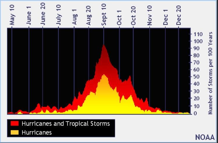
Hurricane season's ultimate peak is Sept. 10 but the season goes through Nov. 30. Credit: NOAA
The peak of the season is Sept. 10, with the most activity happening between mid-August and mid-October, according to the Hurricane Center.
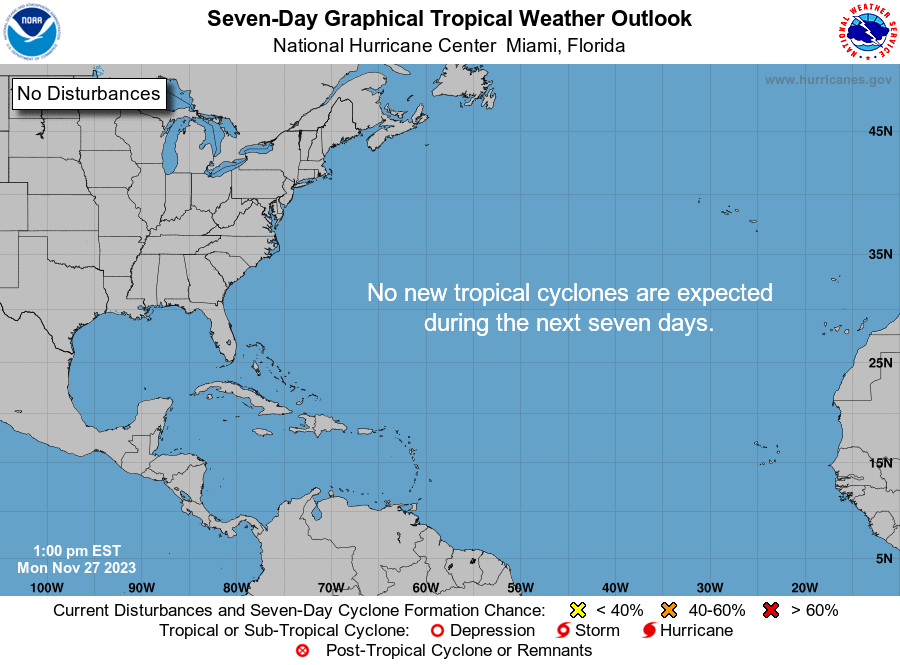
National Hurricane Center map: What are forecasters watching now?
Systems currently being monitored by the National Hurricane Center include:
Interactive map: Hurricanes, tropical storms that have passed near your city
Excessive rainfall forecast
What's next?
We will continue to update our tropical weather coverage daily. Download your local site's app to ensure you're always connected to the news. And look for our special subscription offers here.
This article originally appeared on Florida Today: Track tropic activity: Will tropical depression become Ernesto?